


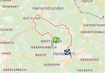

6,8 km | 9,4 km-effort
![Tour Zu Fuß Bergisch Gladbach - [U] Rundweg Asselborn - Schiff - Hombach - Photo](https://media.geolcdn.com/t/1900/400/538de2de-e757-46d2-b801-d02da58106d2.jpeg&format=pjpeg&maxdim=2)

Tous les sentiers balisés d’Europe GUIDE+


Kostenlosegpshiking-Anwendung
 SityTrail
IGN / Geografische Institute
SityTrail World
Die Welt öffnet sich für Sie
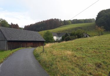
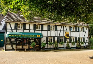
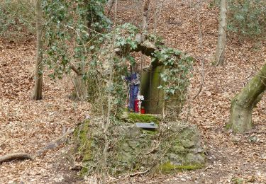
Tour Zu Fuß von 5,2 km verfügbar auf Nordrhein-Westfalen, Rheinisch-Bergischer Kreis, Bergisch Gladbach. Diese Tour wird von SityTrail - itinéraires balisés pédestres vorgeschlagen.
Symbol: U
![Tour Zu Fuß Bergisch Gladbach - [U] Rundweg Asselborn - Schiff - Hombach - Photo 1](https://media.geolcdn.com/t/2048/auto/538de2de-e757-46d2-b801-d02da58106d2.jpeg&format=jpg&maxdim=0 "Tour Zu Fuß Bergisch Gladbach - [U] Rundweg Asselborn - Schiff - Hombach - Photo 1")
![Tour Zu Fuß Bergisch Gladbach - [U] Rundweg Asselborn - Schiff - Hombach - Photo 2](https://media.geolcdn.com/t/2048/auto/8bd16a11-5776-427a-84c8-ec2ff8ab6ac2.jpeg&format=jpg&maxdim=0 "Tour Zu Fuß Bergisch Gladbach - [U] Rundweg Asselborn - Schiff - Hombach - Photo 2")
![Tour Zu Fuß Bergisch Gladbach - [U] Rundweg Asselborn - Schiff - Hombach - Photo 3](https://media.geolcdn.com/t/2048/auto/d7735f17-90a6-4e71-a1eb-b6de2cb25921.jpeg&format=jpg&maxdim=0 "Tour Zu Fuß Bergisch Gladbach - [U] Rundweg Asselborn - Schiff - Hombach - Photo 3")
![Tour Zu Fuß Bergisch Gladbach - [U] Rundweg Asselborn - Schiff - Hombach - Photo 4](https://media.geolcdn.com/t/2048/auto/741756dd-f7b3-41aa-8cee-382402f3cea0.jpeg&format=jpg&maxdim=0 "Tour Zu Fuß Bergisch Gladbach - [U] Rundweg Asselborn - Schiff - Hombach - Photo 4")
![Tour Zu Fuß Bergisch Gladbach - [U] Rundweg Asselborn - Schiff - Hombach - Photo 5](https://media.geolcdn.com/t/2048/auto/b4c98499-7c6c-48c7-916d-724dacbde91e.jpeg&format=jpg&maxdim=0 "Tour Zu Fuß Bergisch Gladbach - [U] Rundweg Asselborn - Schiff - Hombach - Photo 5")
![Tour Zu Fuß Bergisch Gladbach - [U] Rundweg Asselborn - Schiff - Hombach - Photo 6](https://media.geolcdn.com/t/2048/auto/c8a0dca9-325d-483d-a05e-0b568a64746d.jpeg&format=jpg&maxdim=0 "Tour Zu Fuß Bergisch Gladbach - [U] Rundweg Asselborn - Schiff - Hombach - Photo 6")
![Tour Zu Fuß Bergisch Gladbach - [U] Rundweg Asselborn - Schiff - Hombach - Photo 7](https://media.geolcdn.com/t/2048/auto/b5681d97-5413-42fc-b1f7-728a89266cf4.jpeg&format=jpg&maxdim=0 "Tour Zu Fuß Bergisch Gladbach - [U] Rundweg Asselborn - Schiff - Hombach - Photo 7")
![Tour Zu Fuß Bergisch Gladbach - [U] Rundweg Asselborn - Schiff - Hombach - Photo 8](https://media.geolcdn.com/t/2048/auto/12a8f941-4992-43ca-a2c4-f387396186ce.jpeg&format=jpg&maxdim=0 "Tour Zu Fuß Bergisch Gladbach - [U] Rundweg Asselborn - Schiff - Hombach - Photo 8")
![Tour Zu Fuß Bergisch Gladbach - [U] Rundweg Asselborn - Schiff - Hombach - Photo 9](https://media.geolcdn.com/t/2048/auto/cdc33f94-22b8-4bdc-a683-5d8f4fdbe2b9.jpeg&format=jpg&maxdim=0 "Tour Zu Fuß Bergisch Gladbach - [U] Rundweg Asselborn - Schiff - Hombach - Photo 9")
![Tour Zu Fuß Bergisch Gladbach - [U] Rundweg Asselborn - Schiff - Hombach - Photo 10](https://media.geolcdn.com/t/2048/auto/ef2e0038-883e-45a6-bbe7-c4f7e639535d.jpeg&format=jpg&maxdim=0 "Tour Zu Fuß Bergisch Gladbach - [U] Rundweg Asselborn - Schiff - Hombach - Photo 10")
Zu Fuß
Zu Fuß
Zu Fuß
Zu Fuß
Zu Fuß
Zu Fuß
Zu Fuß
Zu Fuß
Zu Fuß